District map
Uttar Pradesh district map
Uttar Pradesh has 75 districts in Maps by India Layer’s boundaries, each with its Local Government Directory (LGD) code. Colour them from your own spreadsheet and export a PNG or an editable SVG.
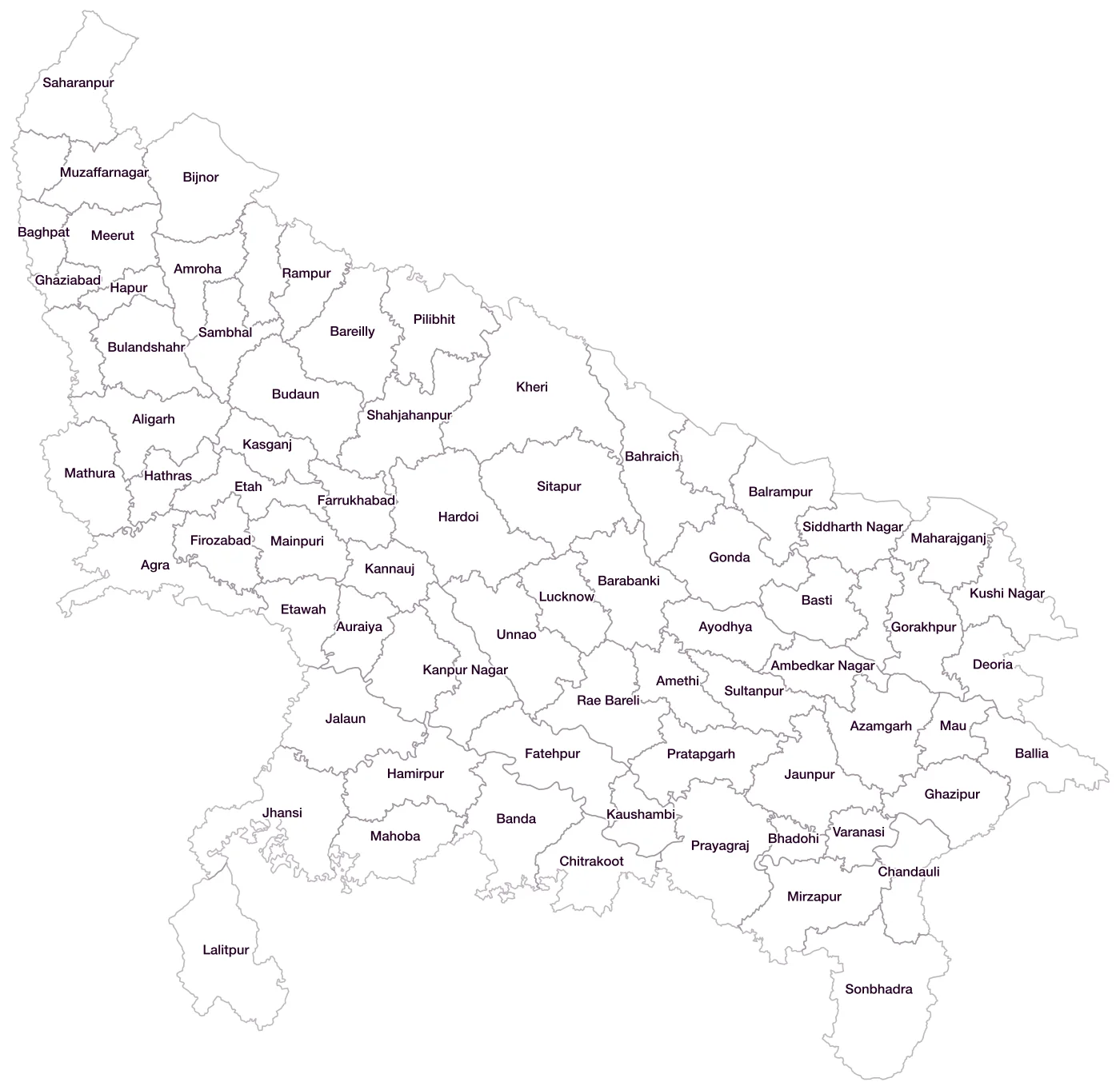
All 75 districts of Uttar Pradesh
- AgraLGD 118
- AligarhLGD 119
- Ambedkar NagarLGD 121
- AmethiLGD 640
- AmrohaLGD 154
- AuraiyaLGD 122
- AyodhyaLGD 140
- AzamgarhLGD 123
- BaghpatLGD 124
- BahraichLGD 125
- BalliaLGD 126
- BalrampurLGD 127
- BandaLGD 128
- BarabankiLGD 129
- BareillyLGD 130
- BastiLGD 131
- BhadohiLGD 179
- BijnorLGD 132
- BudaunLGD 133
- BulandshahrLGD 134
- ChandauliLGD 135
- ChitrakootLGD 136
- DeoriaLGD 137
- EtahLGD 138
- EtawahLGD 139
- FarrukhabadLGD 141
- FatehpurLGD 142
- FirozabadLGD 143
- Gautam Buddha NagarLGD 144
- GhaziabadLGD 145
- GhazipurLGD 146
- GondaLGD 147
- GorakhpurLGD 148
- HamirpurLGD 149
- HapurLGD 661
- HardoiLGD 150
- HathrasLGD 163
- JalaunLGD 151
- JaunpurLGD 152
- JhansiLGD 153
- KannaujLGD 155
- Kanpur DehatLGD 156
- Kanpur NagarLGD 157
- KasganjLGD 633
- KaushambiLGD 158
- KheriLGD 159
- Kushi NagarLGD 160
- LalitpurLGD 161
- LucknowLGD 162
- MaharajganjLGD 164
- MahobaLGD 165
- MainpuriLGD 166
- MathuraLGD 167
- MauLGD 168
- MeerutLGD 169
- MirzapurLGD 170
- MoradabadLGD 171
- MuzaffarnagarLGD 172
- PilibhitLGD 173
- PratapgarhLGD 174
- PrayagrajLGD 120
- Rae BareliLGD 175
- RampurLGD 176
- SaharanpurLGD 177
- SambhalLGD 659
- Sant Kabeer NagarLGD 178
- ShahjahanpurLGD 180
- ShamliLGD 660
- ShravastiLGD 181
- Siddharth NagarLGD 182
- SitapurLGD 183
- SonbhadraLGD 184
- SultanpurLGD 185
- UnnaoLGD 186
- VaranasiLGD 187
Map data for Uttar Pradesh
Paste two columns from Excel, district name and value, and the builder matches each row to its district by name, including older spellings and former names. Your data stays in your browser.
Uttar Pradesh is also available by PIN code (1,635 areas) and Lok Sabha constituency (80 seats).
Boundaries: india-geodata (LGD, Survey of India, DataMeet), CC BY 4.0. District counts follow the boundary release in use (version 2026.09); a district created after that release is not yet on the map. This state page is part of the geography catalogue.
District maps of other states and UTs
- Andaman & Nicobar Islands
- Andhra Pradesh
- Arunachal Pradesh
- Assam
- Bihar
- Chandigarh
- Chhattisgarh
- Dadra & Nagar Haveli and Daman & Diu
- Delhi
- Goa
- Gujarat
- Haryana
- Himachal Pradesh
- Jammu & Kashmir
- Jharkhand
- Karnataka
- Kerala
- Ladakh
- Lakshadweep
- Madhya Pradesh
- Maharashtra
- Manipur
- Meghalaya
- Mizoram
- Nagaland
- Odisha
- Puducherry
- Punjab
- Rajasthan
- Sikkim
- Tamil Nadu
- Telangana
- Tripura
- Uttarakhand
- West Bengal